Brockhaus, 1895 Map of Yellowstone National Park Poster
Vintage Poster Collection
-
Vintage Poster Collection digitally restored and redesigned by local artist, Andrea McDowell.
-
Posters are standard size (20 x 28in) and printed on linen paper for a vintage look and feel.
-
Printed in the USA by a 3rd generation family print shop
Brockhaus, 1895 Map of Yellowstone National Park:
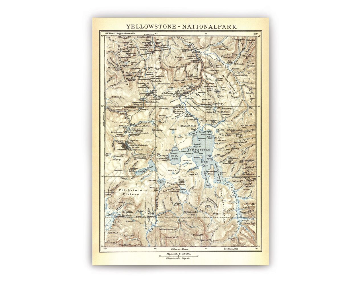
This stunning map of Yellowstone National Park was originally sourced from The Brockhaus Enzyklopädie, a German-language encyclopedia which until 2009 was published by the F. A. Brockhaus printing house. This helps to explain why, though predominantly in English, some German language appears on the map. For example, the cartographer highlights “Kontinental Wasserscheide” in place of “Continental Divide,” and names the “Sud” and “Sud-Ost” arms (South and South East, respectively) of “Yellowstone See” (Yellowstone Lake). The map covers all the major sections of Yellowstone in incredible detail, even spanning the Lamar Valley and the Northeast peaks such as Baronette, Abiathar, and The Thunderer. It also extends to the southern boundary and slightly into Grand Teton National Park. A notable feature in the bottom right section is Two Ocean Pass: a high alpine meadow that’s so low, and so gentle when the meadow is flooded in the spring, fish can swim across and travel from the Pacific watershed into the Atlantic watershed. It’s believed that Two Ocean Pass is how the cutthroat trout originally inhabited Lake Yellowstone following the end of the Pinedale glaciation about 14,000 years ago.
Though information about the cartographer remains a mystery, certain clues can help date when they may have traveled through the area. An unnamed Hotel where the Nez Perce Creek meets the Firehole River would have been the Marshall’s Hotel, later renamed the Firehole Hotel. Built in 1880, it was the second hotel in the park. After eleven years, operations ceased in 1891 and the hotel was razed in 1895 with the exception of a few cabins which were removed later. The inclusion of the Marshall’s hotel serves as a good indicator that the creator of this map traversed the Yellowstone landscape while the hotel was still in operation, before publishing their work in 1895.
Original Artist: N/A. Published by F. A. Brockhaus, c.1895

Andrea McDowell
Yellowstone Love Song
Andrea McDowell is a local artist living in Gardiner, MT.
"Upon stepping foot into Yellowstone, I became filled with the same wonder and excitement that has captivated the hearts of millions before me. The surreal landscape and vivid colors set against a backdrop of primal calls from wolves, elk, bear, and bison gives a shock to the system that never fades. I feel especially influenced by those early artists and explorers whose courage to traverse and passion to preserve this landscape paved the way for our own opportunity to experience its grandeur. My inspiration draws from Life’s invitation to explore both the known and untouched regions of this land, and it’s my honor to keep the legacy of early Yellowstone adventurers alive in my artistic practice as well by uncovering historical maps and works of art, restoring them to their original beauty, reimagining them to fit the scale of a modern day art print, and presenting them on a fine linen paper to preserve the vintage quality of these works."
